This is a Phoenix-local question in its original form, but I intend to answer it from a broader perspective.
What is the forecast for home prices along the light rail route once the route is completed? Boundaries: 7th Ave to 7th St. and Camelback to Thomas.
 The most important thing to understand about the forthcoming Trolley in Phoenix is that it’s built on the wrong route. This was deliberate. The greatest concentrations of bus passengers in Phoenix are in Sunnyslope and in South Phoenix, at either end of Central Avenue.
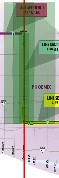
To the right is a Valley Metro map that I have amended. The correct route for the Trolley is shown in bright red, right down Central Avenue. This would move the greatest attainable number of passengers, both from the current Number Zero bus route and from all the transfers from the east/west routes along Central Avenue.
But the purpose of the Trolley is not to move passengers but to move the sympathies of voters, so Valley Metro deliberately picked a route that will serve far fewer passengers but will appease various politically-powerful factions (most especially the millionaires living on Central Avenue between Camelback Road and the Arizona Canal to the north).
But the question before us is: What is the real estate investment value of the Trolley?
The answer? Essentially none.
In the map, the darkest green stripe runs from Camelback south to Washington, from 3rd Avenue to 3rd Street. This region is zoned for high-rise development, subject to Historic Preservation rules and freelance NIMBYism. If any land is likely to be affected by the Trolley, it is this land. But: The people who will make money trading this land will be very experienced land brokers. The people who will lose money trading this land will be punters who think they are getting over on very experienced land brokers.
The middle green band is the land from the Arizona Canal to Washington, from 7th Avenue to 7th Street. This land is ripe, with or without the Trolley. Buy and live, buy and hold, flips, especially tastefully-done historic flips, tear-downs, rezoning for higher-density — there is no limit. People want to be in Downtown and North Central Phoenix, and they will pay premium prices for the right properties.
The lighter green region runs from the Arizona Canal to Washington Street, from 15th (or even 19th) Avenue to 16th Street. This is the spill-over from the North Central Corridor, also in huge demand. Cosmetic and functional flips (e.g., adding a master suite) can do very well.
What does this have to do with the Trolley? Almost nothing. All of these real estate trends have been underway for more than a decade, and all of them would be proceeding apace if the Trolley had met the fate it deserves. Almost none of the people living in upgraded homes or condominiums in those three regions will take the Trolley on a regular basis. They will drive their cars, for all the obvious reasons.
There is more: Transit-Oriented Development zoning overlays actually reduce the uses the land along a Trolley route can be put to, potentially reducing its long-term investment value. You can’t build a new Jack-In-The-Box on Central Avenue, for example, but you also cannot convert your side-yard carport into a garage within the TOD overlay.
All over the West, cities with massive inferiority complexes are building Trolley systems that will fail in a deafening silence. The simple fact is, if you can afford to drive, and if it is physically possible to drive, there is no way that you’re going to take a chance on some wino vomiting on your $200 shoes. All over the country we are building mass transit systems for a mass transit population that does not exist.
In Phoenix — and in most places, I would expect — the investment value of the land along the route of the Trolley system is very, very promising. But it doesn’t have a damn thing to do with the Trolley…
Technorati Tags: arizona, arizona real estate, phoenix, phoenix real estate, real estate, real estate marketing
Allen Butler says:
A fabulous post, and absolutely true, Gregg.
The only places on earth where mass transit of this type works is in densely populated areas. Some examples that come to mind are New York, London, and a few other major cities. The problem, even in those cities, is that the only people who ride mass transit are those people who cannot afford motor vehicles. The example of the derelict and his personal bodily fluids is an apt one. Having ridden the Phoenix bus system ONCE, I have sworn it off. I only took it because I was a teen without a car at the time. See, even teens have some common sense. The Phoenix trolley system is just an aberration. It will fail miserably, and cost taxpayers money in perpetuity. Oh well. . .
February 18, 2007 — 5:23 pm