Our friends in the Gila River Indian Community have elected to negotiate on the location of the Loop 202 Freeway:
In a surprise about-face, the Gila River Indian Community will talk to state and federal officials about the prospect of building the South Mountain Freeway on reservation land, possibly sparing hundreds of homes in Ahwatukee Foothills.
If this is a surprise to you, you don’t understand the economics of casinos. The tribe built one of its three casinos on the route of the planned freeway, and they won’t reap the anticipated windfall if the freeway is not built.
The Loop 202 was originally planned to run on Pecos Road, at the Southern edge of the Ahwatukee Foothills neighborhood. Bonehead developers built very expensive homes very near the freeway’s right of way, and owners of very expensive homes are the very nimblest of NIMBYists. You can hardly blame highway planners for casting an envious eye into the mostly-empty Gila River Reservation.
From west of Phoenix to east and south of Phoenix, from the I-10 to the I-10, the Loop 202 is intended to serve as a reliever freeway, skirting traffic around Central Phoenix. If we view the road strictly as a local route for Ahwatukee Foothills, then Pecos Road in its current configuration is more than adequate. In other words, the reliever function can easily be split from the local traffic problem in Ahwatukee Foothills.
That being so, I like this route better:
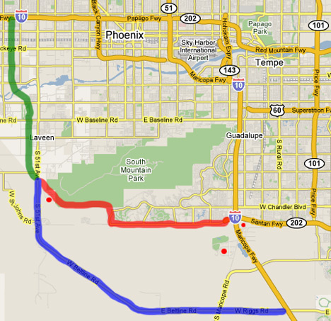
The green line is the currently-planned route for the Loop-202 south from the I-10 west of Phoenix. Everyone on this route wants this freeway, the sooner the better.
The red line is the currently-planned route for the Loop-202 continuing east to the I-10 south of Phoenix. Virtually everyone on this route doesn’t want the freeway to be built.
The bright red dots are the locations of the three Gila River Indian Casinos, vast magnetic cash cows.
The blue line is my suggestion for an alternate route for the Loop 202. It wouldn’t connect with the SR-202 on the east side of the I-10, but it would be a whale of a traffic reliever. In the long run, the SR-101 could extend down to connect with it just west of Sun Lakes.
This is actually one of my Secret Realtor Routes I’m giving away. If I need to get from the West Valley to the Southeast Valley, the blue route, the Beltline Highway, is already a very fast way to go…
Technorati Tags: arizona, arizona real estate, phoenix, phoenix real estate, real estate marketing
Mojo says:
Greg,
The Gial River rep said that the commision was set up to negotiate the widening of I-10 and Maricopa Rd. and the bulding frontage roads for the casinos. Their stance against the loop 202 has not changed.
Why do the tax payers need to pay for freeway construction so that patrons of their reservation can have easy access to their Casinos? I thought they were a soverign nation. I dont see us paying for road consruction in Mexico. It sound slike they dont want the freeway on their land because their feeling are hurt because we did not take them up on their offer to build it on their land 20 years ago.
November 22, 2006 — 12:53 pm